|
|
||
|
|
FORUM:
|
|||||||||||||||||||||||||||
Illustrating Empire: A Soldier's Life and Trans-imperial Encounters in the Eighteenth CenturyLaura J. Mitchell1
|
|||||||||||||||||||||||||||
|
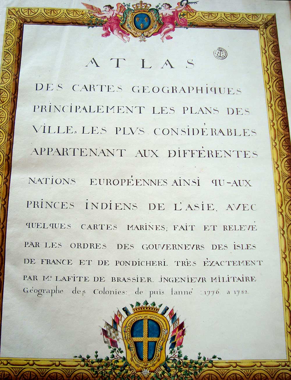
From Paris to Pondicherry, from Sumatra to Nantes, the French empire—like its maritime counterparts—provided means and structure for individuals to travel great distances in the eighteenth century. Most of the details of such crossings and the lives they punctuated are lost to posterity, however. So when we find records of such lives the delight is palpable: flesh and bones and human emotions suddenly animate the theoretical models and large-scale processes prominent in world history scholarship and textbooks. But can one life, however ordinary or remarkable, tell us anything important about world history, bound as that life is to finite geographical points and a limited time span? Historians have long wrestled with this existential question: how can the unique, idiosyncratic details of a single life illuminate the broad patterns of daily experience, the regular thrum of economic exchanges, the structures of governance, or the sinews of affinity that hold society together? Social, economic, political, and cultural historians alike struggle to situate the revealing, intriguing, singular details that bring the past to life within the larger currents of change and continuity that help us make sense of history. Despite the sustained popularity of biography (for "famous" people) and increasing attention to life histories (for ordinary folk), many scholars remain skeptical about how much one person's experience can tell us about the "big picture" questions that tend to drive world history—for example, how rulers managed the flow of information and circulation of people that was crucial to the governance of maritime empires in the eighteenth century.2 By following a French servant of empire into the Indian Ocean, we deepen our perspective on individual mobility in the early modern period and see with new clarity the importance of interactions across imperial spheres of influence. Beginning with Portuguese intrusion into Indian Ocean trading networks inaugurated by Vasco da Gama's 1498–99 voyage, European rulers and their trading-company proxies battled each other, Ottoman forces, African polities, and Asian principalities to secure a segment of the lucrative commerce in luxury goods.3 The French state consolidated the earlier efforts of various merchants and mercenaries by granting a charter to a joint stock company in 1664. This newly formed organization, the Compagnie française pour le commerce des Indes orientales, was founded explicitly to compete against the British and Dutch East India companies, both established more than a half century earlier.4 Anchored in this larger context of early-modern maritime expansion, inter-imperial rivalries, and individual mobility, a study of a single soldier's life does, indeed, reveal mechanisms of imperial rule that are not evident at a macro scale of analysis. Louis Lafite was an ordinary soldier who rose slowly through the ranks, becoming an officer while in colonial service. He was the kind of laboring man whose role in empire-building was structurally unremarkable, one cog among the thousands in service who made the machinery of the Compagnie des Indes, the Armée des Indes, and thus the French empire, work.5 He entered military service in 1755. While a solider he received engineering training and acquired impressive skills as a draughtsman. The attention to detail that he lavished on drawings of fortifications around the Indian Ocean led to a remarkable body of work: watercolor maps made between 1776 and 1782, bound together as an atlas, a repository of geographic and strategic knowledge intended for use by French military planners in Paris, subsequently preserved for nearly 250 years in the state's military archives in Vincennes. Lafite's Atlas des cartes géographiques (Figure 1) is an unusual source base from which to begin a biography. But in this compilation of maps, Lafite left more direct evidence of his work and his travels than in the few letters in his hand that survive among his military service records, most of which were produced by others. So writing Lafite's biography makes two contributions to early-modern world history. First, it complicates imperial history by showing that a single national lens or source base (in this case French) cannot adequately capture early-modern strategies of governance or individual experiences. Second, it addresses a methodological problem for historians: early-modernists trained in textual sources are equipped to work through silences and absences in documentation, but we are less familiar with the challenges of interpreting visual sources, and even less to read those against the grain, gleaning what a draughtsman might reveal about his own life through images intended to convey information about potential military targets.
The value that French officials placed on Lafite's skilled eyes, steady hand, and ability to render military targets legible in two dimensions meant that his work on behalf of imperial expansion was personally identified and preserved, circumstances that set his legacy—though probably not his daily experiences—apart from the masses of soldiers, sailors, clerks, and merchants who similarly labored for empire. Because the state valued his cartographic skills, we know something about Lafite's experiences crisscrossing oceans, traversing imperial boundaries, and making personal connections—both intimate and official—in the French empire he served and Dutch empire he exploited for information. Because of the distances he traveled and the connections he made, making sense of the life of Louis Lafite requires a global framework. Once set in a larger context, Lafite's biography, despite being incomplete, sheds light on the creation and circulation of knowledge, illustrates the ambitions and limits of state power, and shows the significance of person-to-person encounters for empire building during the early modern period. His story also demonstrates how biography as a genre helps us move through scales of analysis from micro to macro and back again, demonstrating that globalized life histories bridge a divide between structure and agency that has vexed historians since the 1970s.6 Finally, the fragmentary evidence of an unknown, un-famous, and un-influential man directly addresses the friction between world historical scholarship centered on large-scale processes and the public reception of global history—where human interest often captures more attention than sweeping conclusions.7 Individual Experience, Imperial Documentation, and Globalist Scholarship Louis François Grégoire Lafite de Brassier, born a subject of Louis XV, spent most of his life serving the French military in the Indian Ocean. He survived at least two round trips to the Indies and one more voyage at least as far as the Cape of Good Hope. His service took him to India, Ceylon, Indonesian principalities, and Cape Town. He married in the colonies and had at least three Asian-born children. His was an imperial, trans-regional life. Between 1776 and 1782 Lafite produced a series of maps of port cities around the Indian Ocean, both European colonial outposts and strongholds controlled by Asian rulers. He completed some of those maps while in France, presumably from notes and sketches he made while still based in Pondicherry, a French outpost on the east coast of India. These images show the relative size of urban settlement, relationships of towns to hinterland, and the relationship of the land to the sea. The maps also include some basic marine chart information: shoals and shallow approaches, navigational points, and often, as in the map of Bombay (Figure 2) ships of various nations anchored in the harbor. These maps are aesthetically pleasing. Lafite clearly took great care in their composition. But they were also made to be specifically functional—a clear communication of military intelligence intended for official use and unlikely to have circulated publically.8
In 1786, at the end of his career as a draughtsman, he went to the Dutch-controlled Cape as a spy on a mission directly authorized by the royal court at Versailles. His life leading up to this point was characterized by long-distance mobility, shaped by the interests of the French empire, guided by Catholic expectations of family structure, and bounded by the conditions of his long military service. The surviving documentation of Lafite's life provides significant anchor points for reconstructing his biography, but it also leaves holes and unanswered questions. The bound atlas contains 25 maps of fortified ports stretching from St. Helena to Macao. In addition, Lafite made two maps and drew a panorama of the Cape of Good Hope in 1786.9 This corpus of visual evidence suggests the breadth of his travels and demonstrates his technical expertise. Written evidence exists in a personnel file that details his relationship with the military, but offers only tantalizing glimpses of his personal life.10 Lafite's life story, then, is available to us through archival fragments currently scattered across imperial collections in France, materials now categorized as relevant to the state's military history (at Vincennes), its wealth of historical maps (in Paris), and its colonial legacy (in Aix-en-Provence). Given the extent, presentation, and preservation of his work in the military archives at Vincenne, his drawings must have been valuable to imperial strategists in Paris and Versailles at some point, even if officials were not quick to reward that work in the early 1780s. History seems no less inclined to appreciate Lafite's work. He is missing from published accounts of French exploits in the Indian Ocean, or French settlements in L'Isle de France and Pondicherry, reinforcing the military bureaucracy's assessment of his service as unexceptional and rendering his life invisible to historians of empire writ large. It is only the aesthetic interest of his watercolor maps and drawings, along with the preservation of twenty-five of them in a lavishly bound atlas that tempted me to look for more evidence of his life. Reassembling Lafite's own interests, aspirations, and contributions is the result of a persistent cultivation of details from sources purposely decentralized by a record-keeping process that was not intended to preserve individual histories and gives them up only grudgingly. This is not an archive story about the chance discovery of a surprising cache of letters or the pursuit of a "smoking gun" document that connects the dots.11 There was no single stone that, once overturned, revealed individual experience long obscured by posterity. Instead, my quest to understand the provenance of Lafite's panorama and maps of the Cape led me into the Indian Ocean, then pointed me back to France to gather what information I could about a forgotten soldier and his family. Framing the life story of ordinary, previously un-known individuals as exemplary of daily life, illustrative of religious belief, or indicative of prevailing moral order has been a staple of early modern historical scholarship rooted in African, Asian, European, Middle Eastern, and U.S. historiographies.12 More recently, world historians have given this approach methodological and theoretical attention, exploring what micro means for a field inherently focused on the global.13 World historians interested in biography have had some success showing the rich detail and frequency of cross-cultural encounters, especially, though not exclusively, among travelers.14 But the full potential of biography to make important arguments in a global context has yet to be realized. Even Linda Colley's masterful The Ordeal of Elizabeth Marsh only goes so far as to argue that the book's subject—an undistinguished woman whose place in a maritime family led her to traverse Atlantic, Mediterranean, and Indian Ocean waters, often in quite remarkable circumstances—was buffeted by global geopolitical and economic forces beyond her control.15 Critiques of canonical world histories that foreground processes of migration, state formation, or the rise of capitalism often remark on the absence of people, or the default to undifferentiated groups of people as actors.16 Explanations that overlook human agency do, indeed, offer a flattened perspective on history. But to argue, as Colley does, that agency is limited by systemic processes does not say anything new, no matter how interesting the story is. Biography set in a global context can to do more than add human interest to process-based explanations of world history. As Colley's and Sanjay Subramanyam's work clearly shows us, individuals transcended national and cultural boundaries in meaningful ways.17 Their work opens possibilities for making life histories global, pushing further than earlier studies by John Demos and Jonathan Spence that addressed traumatic consequences of cross-cultural encounters in the early modern world, but without explicitly connecting the stories of protagonists Eunice Williams or John Hu to global processes.18 Lafite's life story goes one step further to show that following the lives of individuals across imperial boundaries reveals the porous nature of early-modern polities and reveals the contingent, idiosyncratic factors that actually shaped larger processes, rather than only being constrained by them. A Plodding Career in an Imperial Life Louis Lafite was born August 19, 1740 in Roussillon. We know he lived to be at least forty-six years old, that he married in the Indies (perhaps an officer's daughter, or possibly a woman from the local Catholic community) and that they had at least three children. His military record describes him physically: dark hair, blue eyes, big nose, small pox scars.19 The son of a solider, he volunteered for the Regiment of Lorraine at the age of fifteen. We don't know, though, whether he had already survived the pox, or if those scars—like many others—were still to come. In 1756, the year after he enlisted, his regiment sailed to the East Indies where Lafite survived twelve different battles and sieges between 1757 and 1760, until on 17 January 1761 he was captured in Pondicherry. The British held him as a prisoner of war in Bombay until 1765. He returned to France in 1766 where he rejoined his regiment. A year later, he joined the Legion of l'Isle de France at the rank of quartermaster, a transfer approved by Etienne-François de Choiseul, Louis XV's prime minister.20 On Isle de France (present-day Mauritius) Lafite supervised public works projects until he transferred to the corps of engineers for the colony of Isle de France as an officer in 1774. Nineteen years as an enlisted man is hardly suggestive of stellar military accomplishment. Once he joined the engineers, though, Lafite made a tangible and identifiable contribution to the French empire. His career as a cartographer and his circuits around the Indian Ocean began in 1776 when he was ordered to sail for the Seychelles to map the archipelago. He traveled on both merchant and military vessels, calling at Pondicherry, the Malabar coast, and points further east before returning to Pondicherry in 1778. The commander of l'Isle Bourbon (present-day Réunion), Guillaume Léonard de Bellecombe, recognized Lafite's work with a lieutenant's commission. Alas, Lafite had little time to enjoy his new rank. British forces laid siege to Pondicherry beginning in August 1778—the first South Asian hostilities of the Anglo-French war. Outnumbered, outgunned, and undersupplied, Bellecombe finally surrendered in October. French troops, civilians, and their dependents were evacuated and repatriated, including Lafite, his wife, and their children. As soon as he arrived in France, Lafite wrote to Monseigneur de Castries, Minister of the Navy, to let him know about the valuable maps he had drawn and to ask to return right away to Pondicherry. In a letter sent from the Silver Lion inn in Calais, Lafite makes his request clear: "I have the honor to inform you that I arrived in Calais from Pondicherry on the thirteenth of this month [November 1781] with my wife and children . . . I ask for leave from service to take my family home (chez moy)."21 Another hand marked the letter received on 8 December, though it is impossible to know if Castries himself read the letter, or if a clerk simply logged the correspondence. The appeal is the first in a series letters, memorials, and memos from and on behalf of Lafite—an individual assault on the military bureaucracy that lasted for five years. Individual petitions, or memorials, were a common feature of early-modern European governance, with most cases producing a single request, but some produced torrents of paperwork. The clerks managing the flow of information did not keep copies of the initial replies to Lafite's increasingly assertive entreaties—or at least not in the same bundle as his other military records. We can only assume Lafite was not getting the answers he hoped for, because he kept writing, and getting others to lobby for his case. Meanwhile, he launched a parallel assault on the military bureaucracy, trying to secure recognition and compensation for his military service. The surviving paperwork suggests a displaced individual longing for his family domicile and grasping at a financial settlement that would replace the domestic stability they seem to have enjoyed in Pondicherry. In 1782 and 1783 he lodged memorials documenting his 27 (then 28) years of service and asking to be awarded the Cross of Saint Louis, a chivalric order created by Louis XIV and the only order open to non-noble military officers. Intended to acknowledge exceptional service, candidates had to be Catholic and to have served at least 10 years as an officer. Once inducted, knights received a pension, which might explain Lafite's enduring interest in being recognized. His decade with the Corps of Engineers of the Indies just met that qualification, but his case was bolstered by Louis XIV's decree that officers who survived the 1778 siege of Pondicherry should receive two years service credit toward the Cross of St. Louis.22 And of course he served 23 years as a volunteer and non-commissioned officer before rising to lieutenant. Lafite's repeated requests to be acknowledged suggest that his superior officers did not consider his service to be exceptional, despite the quality of the maps he drew. Given the alarmingly high mortality rate of Europeans in the tropics in eighteenth century, mere survival clearly differentiates Lafite from about two-thirds of the soldiers and officers in imperial service. But to receive a knighthood, surviving twenty-five years in the tropics—including four years in a military prison in Bombay, two round-trips from France to the Indies, and multiple sailings among Indian Ocean ports—was apparently not sufficient. A 1782 memorandum supporting Lafite's request notes that, "This officer is an excellent draugthsman (dessinateur)."23 The following year, another memorandum reminds the Minister of the Navy, Marquis de Castries, that Lafite wrote to Castries immediately upon his arrival in France, and sent "very interesting maps of the East Indies that he drew while on a perilous mission." The memo reiterates Lafite's request for the Cross of St. Louis, payment of a stipend already earned for his service, and passage for him and his family to Pondicherry so they could "reassemble the debris of their fortune."24 So Lafite clearly had at least one advocate, but his case was not easily made. From July 1785 his appeals to the King's counselors were incessant. His wife and three children were born in Isle de France and Pondicherry—they needed to return. A second prong of his appeal was material. Their home in Pondicherry had been partly ruined by the siege of 1778. The property was deteriorating, which necessitated the family's quick return—and that, Lafite said, was why he hadn't stopped asking to return to India since they arrived in France. At last, a courtier named Le duc de Villequier intervened; he agreed that Lafite should return to the Indian Ocean.25 Sixteen days later, a letter from Bellecombe authorized Lafite to travel on the first commercial vessel to Pondicherry.26 The king would bear the cost of his passage, and that of his wife and one child; the passage of the other children was at the engineer's expense. This permission came with a major stipulation: that Lafite should make maps of the Cape on his way back to Pondicherry. The Cape of Good Hope was a major geostrategic imperial outpost in the eighteenth century. The harbor on Table Bay was established in 1652 by the Dutch East India Company (known by the initials for its name in Dutch, VOC for Vereenigde Oostindische Compagnie). It was originally intended only to be a resupply station: a harbor with protected anchorage, wharves for loading provisions, access to fresh water, timber for ship repairs, a hospital for sick sailors, and a small company of VOC servants to grow grain and fresh food. The Cape was meant to provide cost-effective support for the VOC's principal trade in spices and luxury goods from its factories in Ceylon and Southeast Asia. Instead the Cape grew awkwardly into a heterogeneous settler colony governed by the Company until 1795, when it was captured by the British.27 Like the other early-modern merchant companies, the VOC could not meet its voracious needs by recruiting or impressing only national labor, so rank and file soldiers and sailors came from across Protestant Europe. The settlement also included indigenous Khoesan displaced by colonial expansion and, after 1657, a growing population of slaves imported to the Cape from throughout the VOC's Indian Ocean strongholds. Cape Town grew quickly into a cosmopolitan city whose port serviced shipping of all the European maritime powers with interests in the Indian Ocean. Shifting alliances and enmities in Europe had consequences at sea and in overseas ports. As the VOC's power appeared to weaken in last quarter of the eighteenth century, both France and Britain had designs on the Cape. In light of the maritime hostilities of the Anglo-French war (1778–1783) and the Fourth Anglo-Dutch War (1781–1784), accurate military intelligence about the Cape of Good Hope would have been valuable to both British and French strategists. Given the quality of the maps Lafite made of other ports and fortifications in the Indian Ocean, the wonder is why it took so long for the French imperial bureaucracy to put him back to work gathering information about allied and enemy positions. When he was dispatched to the Cape in 1786 he possessed cartographic experience, artistic skills, and specific orders. Once there, he went to work and produced two maps and a panorama of the city as seen from the roadstead—a common visual representation of the port settlement by seafaring European artists. Lafite's panorama shares some of the same features as the previous maps he made of other Indian Ocean ports: bright colors, sharp contrast, attention to relationship between town and the surrounding landscape, and the presence of multinational shipping.28 The topographic map that Lafite also drew of the Cape provides an accurate representation of the interior terrain of the colony—making clear the steep, hilly landscape, the relatively small size of the town, and the scattered location of settler farms.29 A second map provides more details about the city itself—a closer view of its situation in the landscape, the hills that encircle the city, and the terrain of the interior. In 1786 the Cape was a settler colony, but also a strategic military target. The harbor at the Cape remained important for supporting long-distance shipping between the spice islands (now in Indonesia and Malaysia) and western Europe. The fort, the Company gardens that grew provisions, the battlements, the barracks, and the VOC's slave lodge that housed subordinated labor are all duly and accurately noted.30 The map's legend is further evidence about what was important for Lafite to tell Louis XIV's military advisors, including the location of the powder magazine and the houses of Company officials and other elite men. This map also provides a detailed census of the population—which exactly matches the official numbers tallied and recorded by the VOC. We have numbers for white Dutch folk (11,884): men, women, boys and girls; black slaves—also by age and gender (14,525) and the soldiers by regiment, 2,400 in all. Officers, Gentlemen, and Men of Science How did Lafite obtain the detailed information conveyed in these three representations of the Cape? Surely he didn't count all those people himself. Presuming a margin of error in any census, it is peculiar that his numbers exactly match the Company's. In addition, the documentation Lafite sent back to France includes the elevation of mountains, and accurate distances between colonial settlements. This suggests—but does not prove—that Lafite received militarily important information directly from the commander of the VOC garrison at the Cape, Colonel Robert Jacob Gordon, a loyal Dutch officer. Gordon was well-known to naturalists and collectors; he wrote in Dutch, French, and English to correspondents across Europe. He communicated directly to senior officials of the Dutch Republic, including the stadtholder Prince Willem V.31 Gordon maintained a small museum in his home and was sought after by knowledgeable visitors to the Cape. Francis Masson, a botanist from the Royal Botanical Garden at Kew, consulted Gordon while he was on a collecting expedition, and Gordon worked closely with the French naturalist and collector François le Vaillant.32 Gordon's papers reveal that he was an active, scientifically-minded interlocutor. He provided botanical samples, animal skeletons, rocks, and fossils to elite collectors in Europe and was genuinely curious about the world in which he lived. Gordon was also a royalist and disciplined servant; the loyalty he showed to the House of Orange in his letters suggests he might not have carelessly or easily supplied strategic information to an enemy officer. But he may well have been willing to share information with a Frenchman who presented himself as a travelling geographer, a corresponding member of the Museum of Paris, a man of property on his way back to India with his wife and children, suggesting Lafite perpetuated a ruse. Gordon inhabited two cultural worlds at the Cape: the official world of the VOC military in a settler colonial society and a larger network of intellectuals, explorers, and natural philosophers whose webs of correspondence crossed linguistic, imperial, and confessional lines to connect Europe to Asia, Africa, and the Americas. If we think about Lafite as one of Gordon's many interlocutors—an intellectual with whom he spoke directly rather than corresponded—then the direct transfer of knowledge from Dutch to French imperial realms is less surprising. In the legend on the topographic map of the Cape, Lafite explicitly credits Gordon for geographical information. Admittedly, these details may have come directly from Gordon, or have been transmitted by a third party. But regardless of the communication protocol, Lafite thought his audience of courtiers and naval officers needed to know the source of his data. It remains an open question whether or not Gordon would have shared that data if he had known it would travel directly to Versailles. Although the Dutch and French states were not at war in 1786, it seems unlikely that Gordon would have shared these details with a French military officer. Gordon might have willingly shared that information with someone he considered a fellow natural historian or man of letters, however. Gordon may have thought that a transfer of information to Lafite was part of an exchange between two academically-minded men, and nothing more. It is in this context that we can envision Lafite as a spy, gathering information specifically to send back to the French court. He was not travelling with troops, or in uniform, but rather on a French merchant ship. Nevertheless, Lafite's presence at the Cape served the larger geostrategic aims of the French Empire. The evidence of French military ambitions lies in the existence of the maps and the drawing, the details those documents communicate, the orders from Versailles, and the congruence between the drawings Lafite made of the Cape and those he drew of other fortifications in the Indian Ocean while in active service. Further evidence that Lafite sought to position himself as a man of letters lies in the faint glimmer of self-identification visible in the archival fragments that comprise Lafite's paper legacy. He signed the back of the panorama as a member and correspondent of the Museum of Paris. With these few words Lafite positioned himself as a member of a fraternity collectors, explorers, writers, and thinkers who shared information with each other regardless of political loyalties. A Place for Global Stories: Connections, Comparisons, Conjunctures The chain of events that took Lafite to the Cape makes for a compelling story. In his work, marriage, property ownership, and travel, we see human interactions at cross-purposes with grand imperial plans, individual lives shaped by imperial ambitions, and the repeated travels of one man who survived many perilous sailings of the Atlantic and Indian oceans. The ability to write life histories of the early modern period is limited by the relatively sparse documentation of daily life of common people. This challenge is compounded when seeking to understand the life trajectories of ordinary folk who crossed administrative or imperial boundaries, leaving records scattered geographically and among many bureaucratic units. Crossing imperial and archival boundaries to recover Lafite's story illuminates the ways in which structures of empire mattered for the lives of ordinary people. Cooper and Stoler's now seminal Tensions of Empire made clear that empire was not a force emanating from the metropole, but instead consisted of mutually-constitutive relationships with considerable weight and agency in the colonies.33 Taking that insight beyond a single imperial framework, Lafite's life history shows how knowledge circulated and demonstrates that information crossed imperial boundaries in significant ways. His work as a cartographer points to the value that key imperial strategists placed on specific forms of knowledge—such as geography—and suggests why some knowledge mattered a great deal to the state, which was willing to fund the travel of a specific individual to get at it. Lafite's five-year hiatus before the state sent him "back to the field" to gather information for new maps likely reflects shifting imperial priorities. Having concluded wars with Britain and 1783 and the Netherlands in 1784, perhaps French imperial strategists were newly ready to contemplate military adventures at the Cape in 1786. Gordon's inquiries, notes, and communication, by contrast, were ancillary to his official position in the VOC. His research was not directly funded or requested by his sovereign or his employer, and he shared his results widely. Consequently, his contributions to natural history are better known—or at lest better documented—than Lafite's geography. Lafite's story, then, reminds us of the accidental, conjunctural, human reasons that people and knowledge ended up where they did. Piecing together the evidence of Lafite's life reveals the personal, idiosyncratic ways that knowledge and power circulated in the eighteenth century—sometimes responding to local, unpredictable needs, rather than the plans of imperial strategists. The ways in which individuals cut across imperial spheres of power reveal a picture of empires that is not monolithic, or centrally controlled, but rather contingent and dependent on the actions of people in the field. Lafite's life matters not because any of his drawings influenced the outcome of imperial battles for control of Indian Ocean trade, but because the process of recovering his story—and telling it for a twenty-first century audience—brings into relief the connections between a single life and imperial structures. His work directly served French imperial expansion in the Indian Ocean. But his efforts did not make a difference when it came to direct military confrontation between France and Britain, or France and the Netherlands. The real narrative tension of Lafite's story is a consequence of France's defeat at Pondicherry—an outcome he could not have influenced directly. In his eventual engagement with a senior Dutch military officer, however, Lafite exercised agency, apparently propelled by the very personal motivation of getting his family back to Pondicherry, rather than his executing the function of a naval engineer. In these ways, our limited view of the life of Louis Lafite reveals mechanisms of imperial rule that are not visible from a macro perspective. Laura J. Mitchell teaches African and world histories at the University of California, Irvine. Her first book, Belongings: Property, Family, and Identity in Colonial South Africa—An Exploration of Frontiers, 1725–c.1830 won the American Historical Association's Gutenberg-e prize. She served a term on the World History Association Executive Council, and co-chaired the AP World History test development committee for five years. She is co-author, with Ross Dunn, of Panorama: A World History, and of The New World History: A Field Guide for Teachers and Researchers with Ross Dunn and Kerry Ward. She also co-edited a volume with Alan Karras, Encounters Old and New in World History: Essays Inspired by Jerry Bentley, due out in June 2017 from the University of Hawai'i Press. She can be reached at mitchell@uci.edu. |
|||||||||||||||||||||||||||
|
|
|||||||||||||||||||||||||||
|
Notes
1 I first shared ideas in this paper at the Southern African Historical Association meeting in 2009. I am grateful to conference and seminar audiences in the intervening years for suggesting reading and posing challenging questions. I am indebted to Victoria Bernal, Rodrigo Lazo, Margot Lovett, Andrea Felber Seligman, and Kerry Ward for reading this iteration of Lafite's biography and providing clear-eye critical feedback. This research would not have been possible without funding from the Mellon Foundation New Directions Fellowship and the University of California, Irvine–Ecole des Hautes Etudes en Sciences Sociales faculty exchange program. I am grateful for this institutional support. 2 For a comparative study of the challenges of imperial rule, see Jane Burbank and Frederick Cooper, Empires in World History: Power and the Politics of Difference (Princeton: Princeton University Press, 2010). 3 Sanjay Subrahmanyam, The Career and Legend of Vasco Da Gama (Cambridge: Cambridge University Press, 1998); K. N. Chaudhuri, Trade and Civilisation in the Indian Ocean: An Economic History from the Rise of Islam to 1750 (Cambridge: Cambridge University Press, 1985). 4 For an overview of the French East India companies and a clear presentation of their economic transactions, see Donald C. Wellington, French East India Companies: A Historical Account and Record of Trade (Lanham: Hamilton Books, 2006). 5 Philippe Haudrère, La Compagnie Française Des Indes Au XVIIIe Siècle, 2. éd. rev. et corr (Paris: Indes savantes, 2005). 6 E. P. Thompson, The Poverty of Theory, or An Orrery of Errors (London: Merlin Press, 1995); Perry Anderson, Arguments within English Marxism (London: NLB, 1980). 7 Trevor Getz, "Making Porous and Expansive Boundaries: Jerry Bentley, World History, and Global Publics," in Alan Karras and Laura J. Mitchell, eds., Encounters Old and New in World History: Essays Inspired by Jerry H. Bentley (Honolulu: University of Hawai'i Press, 2017), 29–41. 8 Lafite de Brassier, Atlas des Cartes Géographiques principalement les plans des villes les plus considérables appartenant aux différents nations Européennes ainsi qu-aux pinces Indiens de l'Asie. Avec quelques cartes marines fait et relevé par les ordres des gouverneurs des Isles de France et de Pondicheri. Très éxactement par M. Lafite de Brassier, ingenieur militaire, géographe des colonies depuis l'année 1776–1782. Service Historique de la Défence (SHD), Vincennes, SH 203. 9 Lafite de Brassier, Carte Topographique et généralle du Cap de Bonne Esperance, 1786, ou l'on voit une grande étendü de Païs habité par les colons hollondais, avec les noms de cartiers et Montaignes. 34 lieus a l'Est et 60 au Nord. Bibliothèque nationale de France (BN), Paris, Cartes et Plans (C&P), SH PF114 Div 6, p 49; Plan de la Ville et des environs du Cap de Bonne Esperance, 1786. BN, C&P, SH PF114 Div 6, p 50; Vue de la baie de la table du Cap de Bonne Espérance, 1786. BN, C&P, SH PF114 Div 1 p 7–1. 10 Lafite de Brassier, Ingieneur Geographie à l'Isle de France. Archives Nationales d'Outre Mer (ANOM), Fonds ministériels (FM), Aix-en-Provence, E.245. 11 For first-hand accounts of approaches to archival research, see Antoinette M. Burton, ed., Archive Stories: Facts, Fictions, and the Writing of History (Durham: Duke University Press, 2005). 12 Carlo Ginzburg, The Cheese and the Worms: The Cosmos of a Sixteenth-Century Miller, trans. John Tedeschi and Anne C. Tedeschi (Baltimore: Johns Hopkins University Press, 1982); Natalie Zemon Davis, The Return of Martin Guerre, Reprint (Cambridge: Harvard University Press, 1984); Jonathan D. Spence, The Death of Woman Wang (New York: Viking Press, 1978); Robert Ross, Adam Kok's Griquas: A Study in the Development of Stratification in South Africa (Cambridge: Cambridge University Press, 1976); John Edwin Mason, "Hendrik Albertus and His Ex-Slave Mey: A Drama in Three Acts," The Journal of African History 31, no. 3 (November 1990): 423–45; Edmund Burke III and David N. Yaghoubian, eds., Struggle and Survival in the Modern Middle East, 1st ed. (Berkeley: University of California Press, 1993); Laurel Thatcher Ulrich, A Midwife's Tale: The Life of Martha Ballard, Based on Her Diary, 1785–1812 (Vintage, 1991); John Demos, The Unredeemed Captive: A Family Story from Early America (New York: Alfred Knopf, 1994). 13 Tonio Andrade, "A Chinese Farmer, Two African Boys, and a Warlord: Toward a Global Microhistory," Journal of World History 21, no. 4 (2010): 573–91; Francesca Trivellato, "Is There a Future for Italian Microhistory in the Age of Global History?" California Italian Studies Journal 2, no. 1 (January 1, 2011), http://escholarship.org/uc/item/0z94n9hq; Kerry Ward, "1745: Ebbs and Flows in the Indian Ocean," in Eric Tagliacozzo, Helen F. Siu, and Peter C. Perdue, eds., Asia Inside Out: Changing Times (Cambridge: Harvard University Press: 2015), 163–185. 14 Sanjay Subrahmanyam, Three Ways to Be Alien: Travails and Encounters in the Early Modern World (Waltham: Brandeis University Press, 2011); Stewart Gordon, When Asia Was the World: Traveling Merchants, Scholars, Warriors, and Monks Who Created the "Riches of the "East" (New York: Da Capo Press, 2007); Ross E. Dunn, Adventures of Ibn Battuta, a Muslim Traveler of the Fourteenth Century (Berkeley: University of California Press, 1994). 15 Linda Colley, The Ordeal of Elizabeth Marsh: A Woman in World History (New York: Pantheon, 2007). 16 William Hardy McNeill, The Rise of the West: A History of the Human Community (Chicago: University of Chicago Press, 1963); Immanuel Wallerstein, World-Systems Analysis: An Introduction (Durham: Duke University Press, 2004); Alfred Crosby, Ecological Imperialism: The Biological Expansion of Europe, 900–1900 (New York: Cambridge University Press, 1986). 17 Colley, The Ordeal of Elizabeth Marsh; Subrahmanyam, Three Ways to Be Alien. 18 Jonathan D. Spence, The Question of Hu (New York: Vintage, 1989); Demos, The Unredeemed Captive. 19 Memorandum, Légion de l'Isle de France, January–February 1770, ANOM FM-E245. No page number. 20 Memoire, 23 June 1782. FM-E245. No page number. 21 Letter from Lafite to Castries, 29 November 1781. ANOM FM-E245, Folio 4. All translations mine. 22 Memorandum, "Colonies." 27 June 1782, ANOM FM-E245; Memorandum, "Colonies." 1 April 1783, ANOM FM-E245, folio 15. 23 Memorandum, "Colonies." 27 June 1782, ANOM FM-E245. 24 Memorandum, "Colonies." 1 April 1783, ANOM FM-E245, folio 15. 25 Memorandum, 8 March 1786. ANOM FM-E245, folio 36. 26 Letter to M. Clouet from Bellecombe, 24 March 1786. ANOM FM-E245, folio 39. 27 On a merchant company as political authority, see Philip J. Stern, The Company-State: Corporate Sovereignty and the Early Modern Foundations of the British Empire in India (New York: Oxford University Press, 2011). 28 Lafite de Brassier, Vue de la baie, 1786. BN, C&P, SH PF114 Div 1 p 7–1. 29 Lafite de Brassier, Carte Topographique, 1786. BN, C&P, SH PF114 Div 6, p 49. 30 Lafite de Brassier, Plan de la Ville, 1786. BN, C&P, SH PF114 Div 6, p 50. 31 R. J. Gordon, Lettres écrites à differentes personnes, Brenthurst Library, Johannesburg, MS 108/13. Correspondence from Gordon to Hendrik Fagel, Nationaal Archief (NA), The Hague, Fagel Archief (FA), The Hague: 1778, FA2015; 1779, FA 2533; 1780, 2543 (1) and 2543 (2); 1783, 2581 (7); 1784, 2600 (11). Letter from Gordon to Prins Willem V, 30 June 1784. Koninklijk Huisarchief, The Hague, Willem V A 31 Inv. Nr. 1838. 32 Francis Masson letter to Joseph Banks, Cape of Good Hope 19 April 1786. Natural History Museum, London (NHM), MSS MAS A. 429259-1001. R. J. Gordon, watercolor drawings. "Quadrupeds," Rijksmusuem Printenkabinet, Amsterdam, RP-T-1914-17b. Patrick Cullinan, Robert Jacob Gordon, 1743–1795: The Man and His Travels at the Cape (Cape Town: Struik Winchester, 1992). 33 Frederick Cooper and Ann Laura Stoler, eds., Tensions of Empire: Colonial Cultures in a Bourgeois World (Berkeley: University of California Press, 1997). See also Clare Anderson, Subaltern Lives: Biographies of Colonialism in the Indian Ocean World, 1790–1920 (Cambridge: Cambridge University Press, 2012). |
|||||||||||||||||||||||||||
|
|
| Home | List Journal Issues | Table of Contents |
| © 2017 by the Board of Trustees of the University of Illinois |
Content in World History Connected is intended for personal, noncommercial use only. You may not reproduce, publish, distribute, transmit, participate in the transfer or sale of, modify, create derivative works from, display, or in any way exploit the World History Connected database in whole or in part without the written permission of the copyright holder. |